


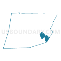
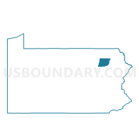
FALLS TWP WD 01, Wyoming County, Pennsylvania
About
Outline

Summary
| Unique Area Identifier | 664683 |
| Name | FALLS TWP WD 01 |
| County | Wyoming County |
| State | Pennsylvania |
| Area (square miles) | 11.66 |
| Land Area (square miles) | 11.12 |
| Water Area (square miles) | 0.54 |
| % of Land Area | 95.33 |
| % of Water Area | 4.67 |
| Latitude of the Internal Point | 41.47195510 |
| Longtitude of the Internal Point | -75.85684560 |
Maps

Graphs
Select a template below for downloading or customizing gragh for FALLS TWP WD 01, Wyoming County, Pennsylvania


Neighbors
Neighoring Voting District (by Name) Neighboring Voting District on the Map
- EATON TWP Voting District, Wyoming County, PA
- EXETER TWP Voting District, Wyoming County, PA
- EXETER TWP Voting District, Luzerne County, PA
- FALLS TWP WD 02, Wyoming County, PA
- NEWTON TWP Voting District, Lackawanna County, PA
- NORTHMORELAND TWP Voting District, Wyoming County, PA
- OVERFIELD TWP Voting District, Wyoming County, PA
- TUNKHANNOCK TWP DIST 01, Wyoming County, PA
Top 10 Neighboring County Subdivision (by Population) Neighboring County Subdivision on the Map
- Tunkhannock township, Wyoming County, PA (4,273)
- Newton township, Lackawanna County, PA (2,846)
- Exeter township, Luzerne County, PA (2,378)
- Falls township, Wyoming County, PA (1,995)
- Overfield township, Wyoming County, PA (1,666)
- Northmoreland township, Wyoming County, PA (1,558)
- Eaton township, Wyoming County, PA (1,519)
- Exeter township, Wyoming County, PA (690)
Top 10 Neighboring Place (by Population) Neighboring Place on the Map
Top 10 Neighboring Unified School District (by Population) Neighboring Unified School District on the Map
- Abington Heights School District, PA (23,623)
- Wyoming Area School District, PA (19,386)
- Tunkhannock Area School District, PA (19,039)
Top 10 Neighboring State Legislative District Lower Chamber (by Population) Neighboring State Legislative District Lower Chamber on the Map
- State House District 117, PA (60,701)
- State House District 111, PA (59,947)
- State House District 114, PA (58,068)
- State House District 120, PA (57,355)
Top 10 Neighboring State Legislative District Upper Chamber (by Population) Neighboring State Legislative District Upper Chamber on the Map
Top 10 Neighboring 111th Congressional District (by Population) Neighboring 111th Congressional District on the Map
Top 10 Neighboring Census Tract (by Population) Neighboring Census Tract on the Map
- Census Tract 4005, Wyoming County, PA (4,351)
- Census Tract 4004, Wyoming County, PA (4,273)
- Census Tract 1124, Lackawanna County, PA (4,266)
- Census Tract 4007, Wyoming County, PA (4,112)
- Census Tract 4006, Wyoming County, PA (3,355)
- Census Tract 2111.02, Luzerne County, PA (2,378)